Find My Plow
Please note: this tool is still in development and some plows may not be displayed. Use the feedback button on the upper right to report bugs and issues.
Plows

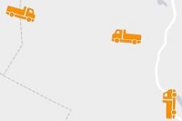
Plows are shown with an orange truck icon representing the last reported position and direction of the truck.
Trails

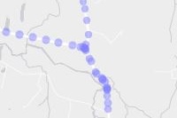
The blue trail shows the recorded path of each truck over the last 90 minutes. Click on a dot to see the time the truck reported passing that location.
Forecasts and Conditions

Click anywhere on the map to see a spot forecast, local temperatures, and detailed maps.
Customize

Click the "Layers" button in the upper right corner of the map to change your view. You can change the basemap and turn on or off any layers you'd like to see. Reload the page to reset to defaults. You can also choose from a variety of base maps. Available layers include:
- National Weather Service Watches and Warnings
- Color Legend - NOAA Precipitation Radar
- County-Level Road Conditions
- Plow Locations
- Plow Paths over the last hour
Please Note:

- This site works best in modern browsers - Chrome, Firefox, Edge, or Safari.
- This map is provided for planning purposes only. Errors or omissions may occur. If you have questions, please use the feedback button in the upper right to contact us.
- This map is based on data transmitted over a cellular network. Like any cell signal, there will be glitches and dead zones. Our plows do not leap over road sections.
- If a transmitter is offline, the truck may appear off the coast of Africa or another invalid location. We are not plowing there.
- Not all trucks are on the road all the time. If you see vehicles clustered at a single location, they are being loaded, serviced, changing drivers, etc.
- Not all trucks are equipped with transmitters. Trucks without transmitters are not displayed on the map.
© 2023 State of Vermont. Radar and warnings courtesy of the National Weather Service and county conditions via New England 511.


